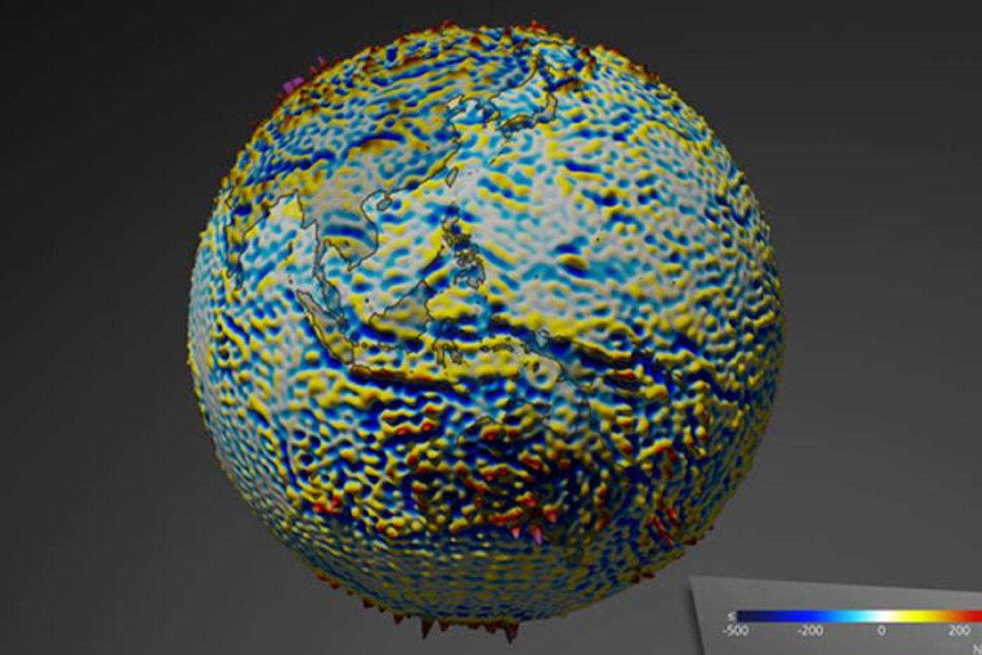
When the Earth’s magnetic field flips, what does that actually mean? Would things change for us when the Earth’s force-field like layer that blocks cosmic radiation and charged particles from colliding into our planet changes its poles? We can begin to understand the answers to these questions better now that a high-resolution map of the lithospheric magnetic field has been published by the European Space Agency (ESA). The map uses data procured from three ESA satellites called Swarm that were put into space specifically to study the Earth’s magnetic fields.
"By combining Swarm measurements with historical data from the German CHAMP satellite, and using a new modelling technique, it was possible to extract the tiny magnetic signals of crustal magnetization with unprecedented accuracy," said professor Nils Olsen from the Technical University of Denmark (DTU), one of the team of scientists who contributed to the new map that was revealed at a Swarm Science Meeting in Banff, Canada.
The lithosphere refers to the rigid outer part of Earth, consisting of the crust and upper mantle. ESA's Swarm mission manager, Rune Floberghagen, explained that "Understanding the crust of our home planet is no easy feat. Measurements from space have great value as they offer a sharp global view on the magnetic structure of our planet's rigid outer shell."
So what exactly are the satellites measuring? Basically, they’re looking at magnetized rocks along the ocean floor that formed when underwater volcanoes erupted and created new crust. Because that new solidifying magma included minerals rich in iron, when it hardened it pointed towards magnetic north, thus capturing a 'snapshot' of the magnetic field in the state it was in when the rocks cooled, explains ScienceDaily. We know from previous studies that magnetic north moves and every few hundred thousand years the polarity flips completely. This means that looking at a compass the orientation points south instead of north. These continued flips have created “stripes” in the minerals that make up the seafloor, and we can use them to better understand Earth’s magnetic field history.
"These magnetic stripes are evidence of pole reversals and analyzing the magnetic imprints of the ocean floor allows the reconstruction of past core field changes. They also help to investigate tectonic plate motions," said Dhananjay Ravat from the University of Kentucky in the USA. "The new map defines magnetic field features down to about 250 km and will help investigate geology and temperatures in Earth's lithosphere." Based on this information, we might be able to determine how a magnetic flipping would affect our planet if we’re around to see it happen!
Sources: ScienceDaily, Phys Link, Latest Technology